I’ll state this right up front: Glacier National Park in Montana is our new favorite National Park. We have plenty more to visit, but we were so impressed by Glacier that I’m not even sure where to begin with writing about it. One thing’s for sure: it’s going to take more than one blog post.
First, a little bit about the park. It’s located in northern Montana, extending up to the border with Canada where it continues as Canada’s Waterton National Park. Its impressive mountains are part of the Rocky Mountains and were initially formed 170 million years ago by the overlap of the Pacific Plate and the North American Plate. More recently the mountains were “carved” by huge glaciers slowly sliding and grinding their way down the mountains during the last ice age, just 20,000–30,000 years ago. This “glaciation” carving activity is what created the many lakes, circular valleys, and steep cliffs throughout the park. In 1910 the area was designated and preserved as a National Park. Visiting the park can be done from the west side or the east—we split our stay by staying on the west side for a few days, then driving all the way around the park to the east side for a few more.

Different layers of rock several feet high along one of our hikes
For our first day in the park, we decided to try something new: a free Ranger-led hike to Avalanche Lake at 9AM. Our Ranger Becky was wonderful, and stopped often to explain the history of the area we were in. She pointed out various types of rocks to explain their origins and why Glacier National Park is so important to geologists. As it turns out, when the two plates collided 170 million years ago, a huge section of earth several miles thick was pushed up and on top of the adjacent land. This brought rock that was 1.5 billion years old to the surface to lay on top of much younger rock. The subsequent glacial activity exposed much of this ancient rock, providing great insights into earth’s history, including “some of the finest fossilized examples of extremely early life found anywhere on Earth” [source: Wikipedia].

Avalanche Creek
Our hike took us along Avalanche Creek (above), carved into the rock by the waters flowing off the melting glaciers and snow fields. At the end of our hike we arrived at Avalanche Lake, a cirque formed by multiple glaciers carving down three sides of the surrounding mountains leaving a bowl-shaped valley with a lake at the bottom. While the hike took much longer than our usual hikes due to being with a large group, the information provided by our Ranger really helped us appreciate the landscape and scenery much more than if we’d hiked alone. We’ll have to consider starting more of our National Park visits this way!

Avalanche Lake and cirque
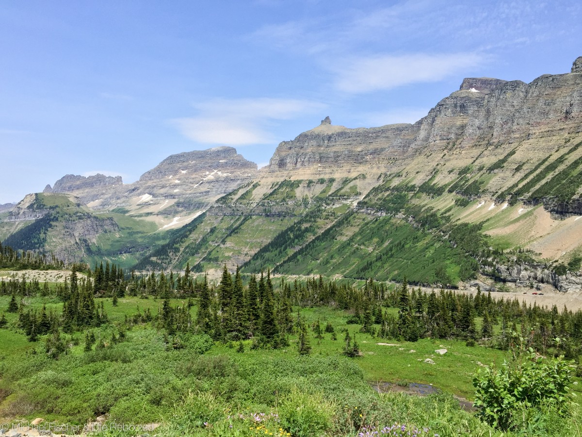
After our hike we drove the Going-To-The-Sun Road (which I’ll call GTTS from now on) which crosses through the park, up and over the continental divide. The road was built from 1921 through 1933 when it opened as an unpaved gravel road. RVs are wisely not permitted, since the road is narrow and often hugs the steep cliff walls on one side with nearly vertical drop-offs on the other.

Part of the Going-To-The-Sun road
The road is a National Historic Civil Engineering Landmark, and certainly seems deserving of the designation. Apart from the difficulties building it, each year snow up to 80 feet deep must be cleared in order to open the road to the public. One thing’s for sure: there’s not a bad view on the road! Every turn and pull-off yields stunning views of the mountains, valleys, and remaining glaciers (the photo at the top of this page was taken from the road).

Haystack Falls passing under the Going-To-The-Sun road
As we’d been warned, traffic (and there was a lot of it) came to a stop at one point on the road as a small black bear leisurely crossed the road. We weren’t fast enough getting our cameras ready but we caught a shot of him as he headed into the woods on the side of the road.

Bear Crossing
We turned around at the Logan Pass Visitors Center about 2/3 of the way through the park. Since we would be relocating to the east side of the park in a few days, we knew we would see the rest of the road from there. The Visitors Center parking lot was packed (it usually fills shortly after 10AM) so we didn’t get to go inside just yet.
Back at camp we started planning for our big hike of the Highline Trail coming up the next day. It was going to be a doozy: 12 miles hiking from Logan Pass to The Loop parking area. Since it starts and ends at different places, we would need to drop our car off at a small parking lot along GTTS Road where the trail ends, then take the free park shuttle to Logan Pass to start the hike. Between the 45 minute drive to the parking lot, 30 minutes waiting for the shuttle and 20 minutes riding it, 6+ hours of hiking, and another 45 minutes back to the campground, we knew Max and Opie would be stuck in Rover for at least 9 hours. We started having second thoughts about doing the whole hike, instead maybe doing half and then backtracking to Logan Pass to avoid the whole shuttle necessity. But more on that in a minute…
When we arrived in Montana we checked into our current RV Park on RVillage, like we always do when traveling. RVillage is a social media web site for RVers, where one of the main features is seeing what other RVillage members and friends are nearby you. If you’re an RVer I highly recommend joining (it’s free!) and keeping your location up-to-date:

RVillage lets you find other RVers near you
Well, Jeff and Sue, another full-time RVing couple had also just checked into the same RV Park as us, so they contacted us and we got together for drinks and snacks outside their Fifth Wheel. Jeff is a software developer, so I had to chat with him for a few minutes about programming languages and web design! Eventually we got to talking about our dogs and our upcoming hike. Well, Sue and Jeff are dog lovers too and offered to take Opie and Max out for a mid-day walk during our big hike the next day! Our minds at ease, we finished our plans for the hike, set our alarm for 5:20AM (we are so not used to using an alarm!) and headed off to bed. Stay tuned for more…

Jeff and Sue, our awesome dog walkers and hiking buddies

I’m so happy that you found Glacier NP as wonderful as I always have. It truly is magnificent!
The Avalanche Creek photo is wonderful!!!
Yeah, those pictures have me thinking about this being on my bucket list now. I can definitely see where the beauty would stop you in your tracks…..
Pingback: Life Rebooted – 2015 Year In Review
Great photos! How long did the ranger hike to Avalanche Lake take you?
It’s a very short and easy hike, but since the ranger stopped often to explain the geology of the area, I believe it took about an hour to get to the lake. Then we all hike back on our own, which only took 15-20 minutes. It was a great way to start at Glacier and get to know the area!