The more traveling around the country we do, the more interesting and useful maps we come across. Below are a selection of maps that you might find interesting, along with a link or reference to the source data wherever possible. Have a favorite map we missed? Leave a comment below!
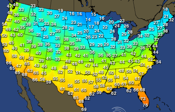
Average Monthly Temperatures
Wondering where to spend the winter months in your RV? Aeris Weather provides a series of maps showing the normal high, low, and average temperatures across the U.S. for each month. You can zoom into various regions (like “Pacific Northwest”) to see more detailed data. For example, below is their map of average high temperatures nationwide in January. http://wx.aerisweather.com/maps/climate/normals/normmax/01/us.html
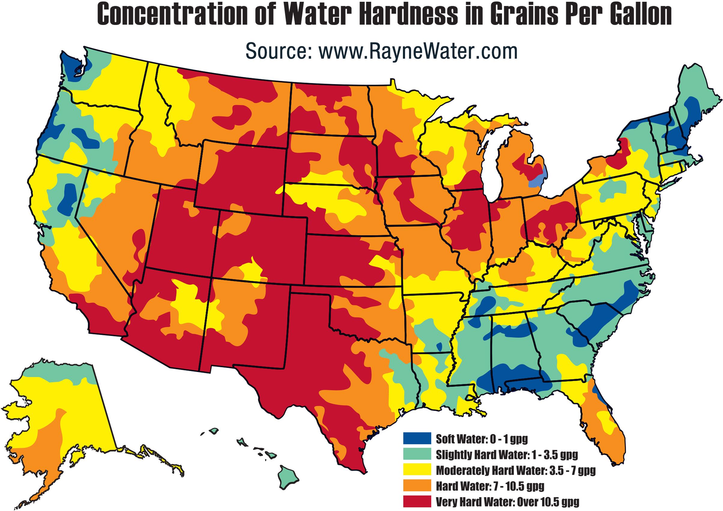
U.S. Water Hardness
Concerned about hard water in your RV? Find out where you might need to use a water softener. There are quite a few water hardness maps out there and they don’t always agree, but here’s one example to start with:
Light Pollution / Night Sky Darkness
Zoom into any area in the world to see what the local light pollution levels are. The less light pollution, the more amazing the night sky will be! http://www.lightpollutionmap.info/

Noise Pollution / Peace and Quiet
Want to find someplace really quiet to camp? The National Parks Service has measured ambient noise levels at 600 listening posts and generated a model covering the entire country. Download an extremely high-resolution PDF version to check out specific places. http://www.nature.nps.gov/sound/soundmap.cfm

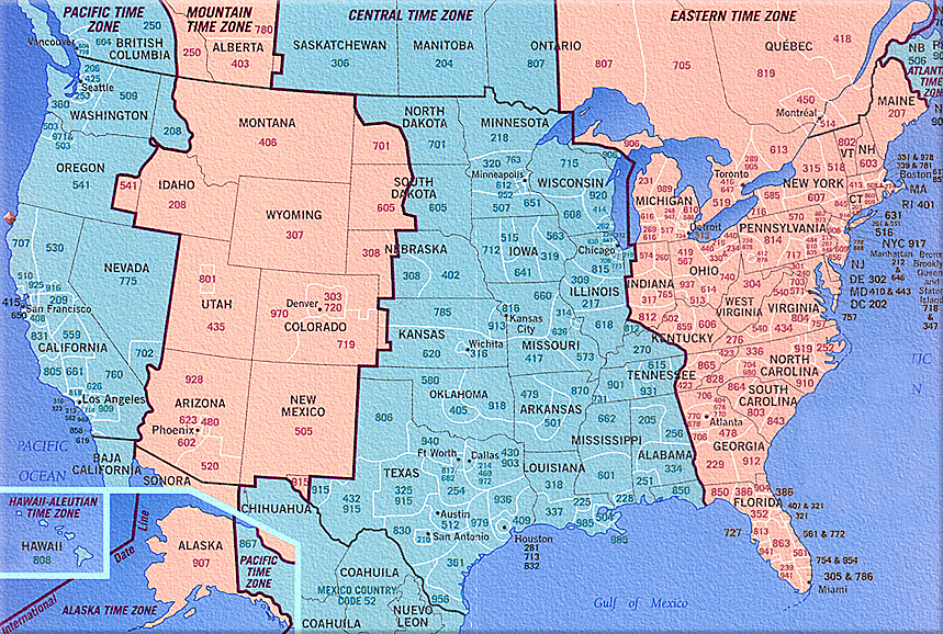
North American Time Zones
Is traveling back and forth across North America getting confusing? Get a handle on time zones with this map. Just keep in mind that Arizona does not follow Daylight Saving Time, so during the summer it matches the time in California, and during the winter it matches the time in Colorado!
U.S. Gas Prices
Added November 9, 2015: We all need gas, and with the GasBuddy price map you can figure out which state to fill up in, and which station has the best price. Special thanks to commenter geraldz for suggesting the gas map.

Sun Angle Calculator
Added November 14, 2015: If you rely on solar panels for energy when boondocking, it can be helpful to know the position of the sun throughout the day. If you tilt your panels, parking your rig so the panels face the sun can make a big difference in solar energy gathered. Just enter your location into the SunCalc map to get a view of the sun’s position relative to you throughout the day! http://suncalc.net/

Do you have other suggestions of maps to help RVers? If so, share your favorites with us and other visitors in the comments!

Cool maps. Here’s one that will help your wallet!
http://www.gasbuddy.com/GasPriceMap
Nice one… I use the GasBuddy app the time, but forgot about the web site. I’ve just added the map. Thanks! -Mike
I’ve been looking for a US map I saw this summer that showed the coverage of smoke from fires. Haven’t found it yet but did run across this table: http://inciweb.nwcg.gov/
PS. Thanks for posting these.
Thanks! I’ll keep my eyes open for the smoke/fire map… -Mike
Thanks for all these maps. Seems like the only one I use is google to map our travels and with the new google maps it isn’t nearly as helpful as before.
If you’re talking about making maps of where you’ve been, this blog post might help out: /creating-route-maps-with-openstreetmap/ … I was using Google Maps but with the new version I could no longer do what I needed, so I switched to this method. It’s definitely a bit “advanced” and isn’t for everyone, but it’s one solution. -Mike
the time zone map made me laugh, you would think they would either (a) just draw a line down from north to south or (b) draw a line along state lines… I wonder what criteria they used?
Great post! Thanks for sharing. :)
Hi! Stumbled on this page accidentally and it’s great! Any plans to update it with current maps? Super helpful!